

MLUI / Articles from 1995 to 2012 / In Leelanau, Frustration About Agriculture Zoning

In Leelanau, Frustration About Agriculture Zoning
New tools needed to respond to accelerating development

June 13, 2004 |
Great Lakes Bulletin News Service
 | |
| MLUI/Gary Howe | |
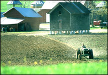
Protecting Leelanau County's farmland and rural character requires new zoning laws that are simultaneously more flexible and more rigorous.
|
Deep in the apparent tangle of laws and rules that most people imagine when they hear the word “zoning” is a basic idea. Zoning helps citizens and local leaders design better places by giving them the authority to decide what can be built and where.
Although there has always been disagreement, most observers generally acknowledge that zoning – separating neighborhoods from polluting industries, deciding the size of buildings, identifying business and historic districts — has worked best where development has already occurred, i.e. in cities.
But with the pace of rural development quickening in most of the nation’s most beautiful scenic areas, the traditional zoning approach that sets hard boundaries for specific activities – like deciding how many houses to allow on farmland that people want to protect — is being exposed as a land management tool that has limited application. What’s needed, say experts, is a new strategy for protecting farmland and scenic areas that is both more flexible and more rigorous at the same time.
The search for such approaches has now reached northwest Michigan’s Leelanau County, which has grown to 22,000 people, 33 percent more than in 1990. During the same period, sales of lots and the construction of 2,400 new homes converted 7,800 acres — 12.1 square miles — of rural land in Leelanau to residential use. Of that amount, 1,500 acres had been productive farmland.
Growth Affects Everybody
The debate about how to respond to the spreading patterns of development affects all of the county’s 11 townships, including Elmwood, the largest. Here, citizens and local officials have been engaged for half a decade in trying to decide what rate of growth is reasonable and what are the highest and best uses for the township’s farmland and open spaces.
Elmwood township planner Bill Swanson has been in the middle of this far-reaching civic discussion, and he has a flair for the dramatic. After a 90-minute interview in which he discussed the breadth of the difficulty in forming a community consensus about Elmwood’s land, population growth, housing, agriculture, and whether existing zoning is useful, he abruptly brought the conversation to a close and jumped in a car with a reporter in tow. Atop a hill about a mile from his office, in the midst of a cherry orchard near the township’s second-highest point, Mr. Swanson swept his arms across a nearly 360-degree panorama of forested hills and blooming orchards, and asked a question that still has no answer in Elmwood, in Leelanau County, and in every other northern Michigan county facing the same levels of growth and development.
“Is this the highest and best use for this land?" he asked, pointing to the young cherry trees not yet producing fruit and a gravel pit below his feet. "I don’t know.”
Miles away Grand Traverse Bay glistened and distant, forested Power Island was clearly visible. He explained that he’s a planner and knows how determined new residents are to be in such a beautiful place. What can a community do to conserve the very values and landscapes that are attractive to new residents and ensure that existing ways of life continue? It’s the most complex political, economic, and cultural issue facing residents and local governments in northern Michigan.
“Think how much people would pay to put a house here,” he said, throwing up his hands.
A 30-Year Search For The Right Answer
Leelanau County townships have been experimenting since the 1970s with zoning strategies for managing growth in rural areas. Three basic approaches have emerged, though none has achieved the goal of preventing sprawl that is set out in the county’s 2000 general land use plan, which established a vision for what Leelanau should look like in the 21st century.
One method, used in Leelanau Township, seeks to protect open space by establishing a special zone that allows homeowners to build only on lots of 10 acres or more. The idea is that by allowing few houses on large blocks of land, the expanse of open land is preserved. However, farmers and planners assert that these so-called “large lots” are really too small to sustain production agriculture and too spread out to efficiently serve with police, fire, and other civic services. Though it doesn’t look like conventional sprawl, large-lot zoning often has the same negative economic and environmental consequences.
The county’s general land use plan is blunt about the consequences of such zoning that leads to “low-density sprawl,” calling it the “major threat to the future quality of life in the county.”
Other townships, among them Empire and Suttons Bay, take a second approach. They provide for zones that allow development in the agricultural area of one house for every one or two acres. These townships believe that by keeping houses closer together, the loss of farmland is slowed. Moreover, zoning that produces higher density assumes that with enough small lots the county will meet growth demands while still keeping plenty of land in agricultural production.
Again, the idea behind the higher density zoning is to provide some management and incentives that allow the county’s villages to expand at a moderate pace on farmland just beyond the village boundaries and still provide certainty to growers that they will have enough land to farm. But this zoning style comes with the very real risk that 100 acres of prime farmland further from village boundaries could quickly turn into an 80-unit housing development.
Elmwood Township, say residents, is in turmoil about whether to embrace high- or low-density zoning for its farming areas. “In Elmwood Township we were worried that one-acre minimum lot sizes would have a sprawl effect. So in 1997 we increased minimum lot sizes to 10 acres. That only exacerbated the problem,” said Mr. Swanson.
Cluster Or Clutter?
A third approach is “clustering,” which, for example, might take 100 acres, put homes close together on 30 of those acres, and permanently sets aside the other 70 as open space. In the last several years, clustering has emerged as a third way that many residents hope will move communities beyond the debate over lot sizes and instead focus on improving the layout and effect of housing developments. Cluster zoning generally allows more homes to be built closer together, which is an incentive to builders. And because clustering also provides for protecting open land, residents have found the approach attractive.
But clustering has drawn more scrutiny in Leelanau County because critics see it as sprawl in sheep’s clothing. The reason: Clustering provides builders with incentives to still fling new subdivisions into the county’s most rural regions. “If we hide sprawl, it’s not enough, it’s still sprawl,” said Steve VanZoeren, a resident and leader of Elmwood Citizens for Responsible Growth, a citizen group that is concerned about a proposed clustered development that could allow as many as 500 new homes in the township. “The increase in traffic will be the same and the increased demand on services will be the same – all that is different is that the houses are hidden.”
Farmers, too, are worried about clustering because it still pushes residential housing toward working farmland. Bill Casier, a farmer who runs Sleeping Bear Orchards in Empire, knows the troubles farmers face when houses spring up next door. “There is a farm around here that is about to go out of business," he said, "largely because new subdivisions were just put in on three sides, and it is going to be too problematic to keep farming. People complain about odor and noise. You have to alter the way you farm.”
While the intent of clustering is to give township planners greater say in designing new developments and in preserving open space, the actual result is often something different. Bingham Township resident Phil Anderson, a leader in Retain Bingham Character, a citizen advocacy organization, says developers are taking advantage by building conventional subdivisions that they market as “cluster development.”
“Developers pick and choose the aspects of clustering that benefit them," said Mr. Anderson. "Then they put a little open space in the back and call it good."
In the last year, citizens formed new land use advocacy organizations in Elmwood, Bingham, and Leland townships to express concern about how builders were applying cluster development techniques to new projects. Citizens halted proposed clustered housing projects that they argued were really out-of-scale developments that threatened the very rural character clustering promised to protect.
Model Tool In Charlevoix County
Frustrated, these same organizations are starting to look to new zoning tools tested in Marion and Evangeline townships across the bay in Charlevoix County. One tool that has attracted particular attention allows townships to specifically set boundaries on the active and productive farm land in their jurisdiction, and limit the number of acres available for new housing. In essence, Marion and Evangeline townships define farming as a top priority that they will defend. The zoning rules provide community leaders with new authority to give farmers the right to preserve the land base that they need. The rules also limit the number of acres in the farm area that can be developed for housing and other non-farm uses.
Marion and Evangeline townships have moved well beyond the reactionary arguments of “property rights” advocates, who wrongfully assert that any government intervention in the uses of land is illegal, and have focused on establishing strict limits on housing in order to preserve large stretches of agricultural land where farmers want to keep farming. Both townships encourage builders to seek land that isn’t useful for agriculture and is close to existing developed areas. The approach guarantees farmers the right to farm their land without fear of development pressure or a neighborhood subdivision springing up next door.
The question is whether farmers are as determined to help townships do the same thing in Leelanau County. Talk of limiting growth on farmland in this conservative county is certain to raise worries that protecting farmland means taking away the right of farmers to sell their land. In interviews, people generally agreed that farmers, whose primary investment is in the land, have the right to sell some land in order to make ends meet or to pass on land to the next generation.
But while respect for farmers’ rights is nearly universal, many residents are also convinced that rampant speculation will ruin the county and that some combination of zoning protections and public resolve to enforce them is crucial. “We are talking about greed here,” said Leland Township resident Gil Bogley, who has become active in farmland development issues. “These developers stand to make huge profits but don’t feel the need to develop responsibly.”
Jess Piskor, a native of Suttons Bay who graduated this year from the University of Michigan, is a Leelanau Smart Growth Coalition intern working out of the Michigan Land Use Institute’s regional office in Traverse City. This is his first article for the Great Lakes Bulletin News Service. Reach him at jess@mlui.org.
