

MLUI / Articles from 1995 to 2012 / Dangerous Roads, Dirtier Air

Dangerous Roads, Dirtier Air
New assessment finds Michigan sprawl causes traffic deaths, pollution

October 17, 2002 | By Keith Schneider
Great Lakes Bulletin News Service
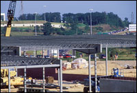 | |
| Patrick Owen/MLUI | |
| In sprawling places people drive more, own more cars, breathe more polluted air, face a greater risk of traffic fatalities, and walk and use transit less, according to a new study by Smart Growth America. |
LANSING – A new measure of the consequences of urban sprawl concludes that people who live in the Detroit region, which has done little to reign in its spreading development, face a greater risk of dying in a traffic crash and breathe more polluted air than people who live in less sprawling areas.
The assessment by researchers at Rutgers University and Cornell University also found that Grand Rapids, where growth management policies are beginning to take effect, fares considerably better but nevertheless still experiences the effects of urban sprawl that diminish the region’s quality of life.
“Detroit can do so much to improve its quality of life simply by growing smarter,” said Conan Smith, the director of land programs for the Michigan Environmental Council in Lansing. “This study demonstrates the very real impact that sprawl has on people’s everyday lives. And it provides a broad set of specific indicators that we can use to track trends and see the success of the policies that we are working on.”
A New Tool for Measuring Sprawl
The study, Measuring Sprawl and Its Impact, was made public today by Smart Growth America, a Washington-based land use research and advocacy organization. The study applies a new and comprehensive measure of sprawl’s myriad effects to 83 metropolitan areas across the nation. The indexing tool was created by Reid Ewing, an engineer, planner, and research professor at Rutgers University’s Urban Policy Center, and Rolf Pendall an associate professor in the Department of City and Regional Planning at Cornell University.
The study, nearly three years in the making, was subjected to academic peer-review. “This comprehensive and academically rigorous study truly breaks new ground by going a step beyond the index to demonstrate how sprawl development patterns affect the way people live,” said Don Chen, executive director of Smart Growth America: “For the first time we are able to define sprawl objectively so can see how it measures up. We are confident that for the first time policy makers and planners can draw some definitive conclusions about sprawl and its impact.”
A Bonafide Public Concern
Since the mid-1990s, concern about the affects of urban sprawl on the environment, public health, the economy, and the quality of life has steadily grown as a public concern in most states. Sprawl has several dimensions, according to Smart Growth America. It is principally characterized by a population widely dispersed in low-density development; rigidly separated homes, shops, and workplaces; a lack of well-defined and thriving town centers; and a road system marked by very large blocks and dead-end streets.
Most of the other features usually associated with sprawl—the lack of transportation choices, relative uniformity of housing options or the difficulty of walking—are a result of these conditions, said the organization.
More Cars, Greater Hazards
The findings in Smart Growth America’s new study put a statistical confirmation to observations that citizens, local government leaders, and critics of sprawl have been making for years. In sprawling places people drive more, own more cars, breathe more polluted air, face a greater risk of traffic fatalities, and walk and use transit less. This holds true in Michigan and other states, according to the study, even when controlling for income and other demographic factors
The report also found that the distances people drive increase ten miles a day in the most sprawling places than in the least sprawling, which not only adds to traffic, but makes driving much more dangerous.
The ten most sprawling places average 36 traffic deaths for every 100,000 people, while the least sprawling places average 23 deaths per 100,000. In Riverside, California, the most sprawling region according to the index, 49 of every 100,000 residents die each year in traffic crashes. The New York metropolitan area, the least sprawling region, had 12.54 traffic deaths for every 100,000 residents, or 75 percent less.
The study also reached these conclusions:
- Ozone pollution levels are as much as 41 parts per billion higher in the most sprawling areas, which in some places can mean the difference between meeting federal health standards and violating them.
- Households in sprawling areas own more cars. In the ten most sprawling metropolitan areas, there are 180 vehicles to every 100 households; in the least sprawling metro areas (excluding NY and Jersey City), there are 162 cars to every 100 households. Sprawl means more driving and higher automobile expenses.
Detroit, Grand Rapids Results
Overall, Detroit is the 15th most sprawling region in the country and the most sprawling big city in the Midwest. It scored particularly low in the index that measures the strength of its urban center, which reflects the fact that Detroit lost one million people since the 1960s, or half of its population. Many of those people settled in Washtenaw, Monroe, and Macomb counties outside Detroit, which have become among the most congested suburban counties in the nation.
The Detroit area ranked 55th in transit use with fewer than two percent of commuters riding the bus — roughly a third of the study average. It had the 10th worst walking to work rate in the study, far behind cities like New York, Chicago and Milwaukee that have similar climates. As a result, the annual traffic fatality rate in the region is 25.16 per 100,000.
The Grand Rapids region ranked 36 out of 83 metropolitan regions that were studied, or roughly in the middle of the pack. Grand Rapids scored particularly well in the strength of its downtown and urban neighborhoods, which appears to reflect the considerable work by the region’s business community and local governments in recent years to invest in town centers and curb sprawl in the rural areas.
Grand Rapids, though, had a 25 percent higher rate of traffic deaths than the Detroit region, which the researchers attributed to greater reliance on the region’s highways and an inaccessible street network.
The scores in Measuring Sprawl are based on dozens of statistics from national databases and represent the first comprehensive, academically rigorous ranking of sprawl in the United States. The full report, as well as a technical research paper and metropolitan area fact sheets can be found at www.smartgrowthamerica.org.
“This study is the first to offer a clear picture of the relationship between sprawl, driving and their spinoff effects,” said Smart Growth America in a statement.. This shows us that sprawling development has real consequences for the way we live our daily lives: it means more traffic, more pollution, and less choice.”
Keith Schneider is the program director of the Michigan Land Use Institute. Reach him at keith@mlui.org. For a copy of Measuring Sprawl, see Smart Growth America’s Web site at www.smartgrowthamerica.org.
